| 12 Caroline Place, Birkenhead (edit) |
|
|
|
|
|
53.386665, -3.043356 |
|
Clara Croskery (née Nicol) |
|
| 15A Ashburton Terrace (edit) |
|
|
File:FSPS Ashburton Terrace, No 15A, 10-2-A, 1978.pngFSPS Ashburton Terrace, No 15A, 10-2-A, 1978.png |
FSPS Ashburton Terrace, No 15A, 10-2-A, 1978 |
|
-32.06143, 115.75752 |
|
|
FSPS |
| 17 McCleery Street (edit) |
|
|
File:FSPS McCleery Street 002, No 17, 18-2-A, 1979.pngFSPS McCleery Street 002, No 17, 18-2-A, 1979.png |
FSPS McCleery Street 002 |
FSPS photo from 1979.
|
|
|
|
|
| 2 Ada Street (edit) |
|
|
File:FSPS Ada Street, No. 2, 16-4-E 1978.pngFSPS Ada Street, No. 2, 16-4-E 1978.png |
|
|
-32.06636, 115.751 |
|
|
FSPS |
| 2 Barnett Street (edit) |
Q73008071 |
|
File:FSPS Barnett Street 02, no 2, 7-4-G 1980.pngFSPS Barnett Street 02, no 2, 7-4-G 1980.png |
FSPS Barnett Street 02 |
The house in 1980, taken as part of the FSPS.
|
|
Barnett Street, Fremantle |
|
Barnett Street, Fremantle • Quarry Street |
| 20 Highfield Crescent, Rock Ferry (edit) |
|
|
|
|
|
53.368532,-3.013713 |
|
Samuel Maxwell West Croskery |
|
| 21 Curedale Street (edit) |
|
|
File:FSPS Curedale Street 001, no 21, 18-8-9, 1978-80.pngFSPS_Curedale_Street_001,_no_21,_18-8-9,_1978-80.png |
|
Photo from the FSPS.
|
|
|
|
Curedale Street, Fremantle • Martha Street East |
| 223 South Terrace (edit) |
|
|
|
|
|
|
|
|
|
| 3 Chester Street (edit) |
|
Coordinates are approximate.
|
|
|
|
-32.06812, 115.7557 |
|
|
|
| 53 Attfield Street (edit) |
|
|
File:FSPS Attfield Street, no 53, 13-3-E.pngFSPS_Attfield_Street,_no_53,_13-3-E.png |
|
FSPS photo
|
|
|
|
|
| 7 Chester Street (edit) |
|
location approx.
|
File:FSPS Chester Street 002, No 7, 19-1-B, 1978.pngFSPS Chester Street 002, No 7, 19-1-B, 1978.png |
|
|
-32.06839, 115.75548 |
|
|
FSPS |
| 8A Outram Street (edit) |
|
|
|
|
|
-31.951013, 115.838607 |
|
|
|
| 98 Herbert Road, Shenton Park (edit) |
|
|
 Glass negatives box 7, 1200 dpi, 16 bit 001 (cropped).jpg Glass negatives box 7, 1200 dpi, 16 bit 001 (cropped).jpg |
Edith Wilson at 98 Herbert Road, Shenton Park, April 1950 |
|
|
|
|
|
| Ada Street (edit) |
|
|
|
|
|
|
|
|
|
| Adelaide Street, Fremantle (edit) |
Q4681786 |
|
|
|
|
|
|
|
|
| Andover Station (edit) |
Q98205408 |
|
|
|
|
|
|
|
|
| Atlas Building (edit) |
|
Building on the corner of Sherwood Court and The Esplanade, Perth, Western Australia.
|
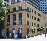 Atlas_Building,_Perth.jpg Atlas_Building,_Perth.jpg |
|
|
|
|
|
|
| Attfield Street, Fremantle (edit) |
|
|
|
|
|
|
|
|
|
| Beaconsfield (edit) |
|
|
|
|
|
|
Fremantle |
|
|
| Carnarvon (edit) |
Q1021880 |
|
|
|
|
|
|
|
|
| Chester Street, Fremantle (edit) |
|
|
|
|
|
|
|
|
South Fremantle • Streets in Fremantle |
| Cook and Munday grave, Melbourne Cemetery (edit) |
|
|
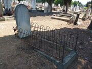 2539_2015-03-03_1014_4000x3000.jpg 2539_2015-03-03_1014_4000x3000.jpg |
|
|
|
|
James William Munday • Alice Rose Munday (née Cook) |
|
| Cossack (edit) |
|
|
|
|
|
|
|
|
|
| Cottesloe Sugar Refinery (edit) |
|
|
|
|
|
|
|
|
Mosman Park • Factories |
| Croydon Station (edit) |
Q5189705 |
|
|
|
|
|
|
|
|
| Dunollie (edit) |
|
|
|
|
|
-31.9842504, 115.7698971 |
|
|
|
| Fitzgerald Street (edit) |
|
A street in Perth.
|
|
|
|
|
|
|
|
| Garden Lake (edit) |
|
|
|
|
|
|
|
|
|
| Grave of Ernest Anderton Frank Hall (edit) |
|
|
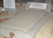 2018-03-30_1836_EAF Hall grave.JPG 2018-03-30_1836_EAF Hall grave.JPG |
|
|
-31.966965875646785, 115.80342538587749 |
|
Ernest Anderton Frank Hall |
|
| Hall's Cottage (edit) |
|
A single-storey stone house in Mandurah that was originally the home of Henry Edward Hall and his family.
|
 glass slides 4. Hall's Cottage, MAndurah circa 1904 006.jpg glass slides 4. Hall's Cottage, MAndurah circa 1904 006.jpg |
Wilson family glass negatives/Box 4 |
|
-32.53362, 115.71357 |
|
|
|
| Jarman Island (edit) |
Q21888197 |
|
 Jarman Island from Reader Head.jpg Jarman Island from Reader Head.jpg |
|
|
|
|
|
|
| Jennacubbine (edit) |
Q21888227 |
|
|
|
|
|
|
|
|
| Linlathen (edit) |
|
|
|
|
|
|
|
|
|
| Marvel Loch (edit) |
Q6778173 |
|
|
|
|
|
|
|
|
| Millstream (edit) |
|
|
|
|
|
|
|
|
|
| Morant (edit) |
|
|
|
|
|
|
|
|
|
| Mount Satirist (edit) |
Q94984046 |
|
|
|
|
|
|
|
|
| Olivia Terrace, Carnarvon (edit) |
|
|
|
|
|
-24.887329, 113.656491 |
|
Harold Aubrey Hall • Helen Rose Hall (née Lodge) • Helen Margaret Wilson (née Hall) |
|
| Roebourne (edit) |
Q941071 |
|
 Holy Trinity Church and Rectory, Roebourne (Slwa b3824163 2).jpg Holy Trinity Church and Rectory, Roebourne (Slwa b3824163 2).jpg |
|
|
|
|
|
|
| Rottnest (edit) |
|
|
|
|
|
-32.003162, 115.517774 |
|
|
|
| Sherlock Station (edit) |
Q7495094 |
|
|
|
|
|
|
|
|
| Strelly Grange (edit) |
Q96248693 |
Lodge family house in Busselton, Western Australia.
|
 Family at Strelly, Busselton, cropped 1.png Family at Strelly, Busselton, cropped 1.png |
|
|
|
|
|
|
| Tambellup (edit) |
|
|
|
|
|
|
|
|
|
| Template:Place/preload (edit) |
|
|
|
|
|
|
|
|
|
| Woodbrook Station (edit) |
Q137970611 |
|
|
|
|
|
|
|
|
.jpg)


.jpg)


